The Zagros .... breath-taking scenery, fantastic geology, the most hospitable people you’ll ever meet. And a lot of very large, spectacular anticlines. Yet despite more than one hundred years of exploration, the Zagros region remains under-explored and under-developed. Don’t be misled by the apparent simplicity of map-scale folds; stratigraphic and structural heterogeneities are widespread, and there are structural complexities that simply can’t be identified remotely, even with today’s ultra-high resolution satellite imagery.
We have extensive “boots-on-the-ground” field experience in the Middle East, and since 2009 we have carried out twenty-six successful field campaigns in the northern Zagros, totalling many hundred field days, in over 40 license blocks, for 19 companies, covering an area of over 20,000 sq.km.
- We have detailed outcrop knowledge of Cambrian-Pliocene stratigraphy, and a broad understanding of the structural complexities throughout the region.
- We enjoy close collaboration with colleagues in Durham University with wide experience of the Iranian Zagros.
- We work extensively with sub-surface interpretation based on integration of surface geology, satellite imagery, published and proprietary information, and sub-surface geophysical and well data.
- Construction of cross-sections for regional and detailed anticline studies includes 150 balanced Zagros sections more than 8,000 km.
- We have comprehensive logistical capability, and our field teams are ready for bespoke single-client projects, as well as our own multi-client studies.
Zagros Regional Mapping (Iran, Iraq and SE Turkey)
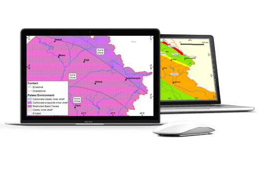
Vector-based geological maps showing stratigraphy and structure for the entire Zagros range, ready for import into ArcGIS, GoogleEarth, Petrel, GoCad or your favourite G&G software. Featuring our high resolution ZOOM data (Zagros Outcrop Oriented Mapping) for the northern Zagros, based on very extensive field mapping throughout the region. Sub-surface interpretation is richly illustrated with a series of regional balanced cross-sections. Our stratigraphic correlation chart also includes surrounding regions in NE Syria, Saudi Arabia, UAE and Oman. The most comprehensive, structurally valid Zagros maps available.

Regional Appraisal of Fractured Reservoirs (NE Iraq)
Let us use our wide experience of fracture characterisation in all Cenozoic and Mesozoic reservoir units in Kurdistan & neighbouring areas of NE Iraq to help you to high-grade potential acreage and bench-mark expected fracture potential. Includes summary tables and composite stratigraphic columns with our assessment of fracture ‘quality’ for 43 formations, reflecting the mechanical stratigraphy that we’ve studied extensively in outcrop throughout the region. Risking is aided by our appraisal of typical heterogeneities and variability seen laterally and vertically. Updated in 2017-18 to include 56 vector-based map overlays (shapefile and KMZ formats), showing interpreted spatial variations in fracture quality, seal risk, structural complexity, and hydrocarbon occurrence, for Permian to Pliocene reservoir formations.

Detailed Fracture Characterisation, Cretaceous, Jurassic and Triassic (Kurdistan Region of Iraq)
Very detailed, comprehensive analysis of Cretaceous, Jurassic and Triassic fractured carbonate reservoirs, incorporating extensive fieldwork across the Kurdistan Region of Iraq. Based on a combination of traditional fracture transect measurements and leading-edge geospatial technologies (lidar, photogrammetry, satellite analysis), acquired during more than 300 field days, these products provides an exhaustive set of quantitative fracture parameters that you can import directly into your fracture modelling workflow. Logged outcrop sections, including gamma-ray and mechanical properties, help to ensure valid correlation with the sub-surface.

Which Zagros Data Package is right for your requirements?
Zagros Regional Mapping & Balanced Cross-Sections
- Area: Iran, Iraq, South East Turkey
- Target: Exploration
- Content: GIS structure & strat maps, balanced cross-sections, correlation charts
- Purpose: To provide outcrop-scale to regional maps, linking surface stratigraphy and structure to sub-surface interpretation
Regional Appraisal of Fractured Reservoirs
- Area: Kurdistan & NE Iraq
- Target: Early Exploration
- Content: GIS overlays, fracture assessment, seal risk, structural complexity, hydrocarbon occurrences, for all reservoir units
- Purpose: To help high-grading of potential fractured reservoirs and identification of target acreage
Detailed Fracture Characterisation
- Area: Cretaceous, Jurassic & Triassic Reservoirs, Kurdistan Region of Iraq
- Target: Late exploration, development, production
- Content: Detailed extensive quantitative fracture parameters
- Purpose: To provide carefully constrained direct inputs for fracture modelling (e.g. DFNs) and well planning
Contact GRL Now:
+44 (0)191 384 1759
